
There Was Once an Asylum

This site not only provides an overview of mental health history and its implications for Goodna, but also explores the complex relationship between memory and history.
There are stories we may never know, but this site uncovers the history, revealing the layers of understanding that underpin the present.
It is done in a way that honours the patients, clients, and the people.


Female Patients' Recreation Area
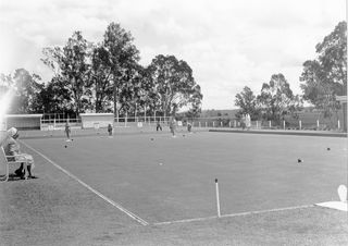
While male patients had spacious outdoor recreational amenities since at least 1895, most notably the cricket oval, no similar facilities existed for female patients. In keeping with gender stereotypes, the recreational opportunities provided for females were restricted to indoor 'domestic' type activities such as needlework. In 1946, Medical Superintendent Boyce proposed the construction of a special female recreation area. The rationale for such a facility was that it would provide 'a more congenial environment to assist patients towards recovery'. More pragmatically, an area where female patients could spend part of the day.
Despite the completion of a new female block with accommodation for 60 residents, overcrowding was still a major problem. The need to fill almost every available space with beds, such as verandahs and corridors, resulted in an even more acute shortage of space for daytime activities. Only a limited number of patients could undertake needlework or work in the sewing rooms or laundry. The remainder were confined to sitting about in an extremely cramped environment. The Director of Mental Hygiene, Basil Stafford, endorsed the idea and, in March 1948, reported that the 'scarcity of a recreation area for a large number of female patients is a considerable handicap in the administration of this hospital'. An area of approximately 2.5 hectares on the western edge of the reserve, adjacent to the Brisbane River, was selected. Pm of the area occupied the site of the original male wards, and ironically, a portion comprised a low-lying area that was originally designated in the 1860s to be laid out as pleasure grounds. Construction of facilities and landscaping commenced in 1951. The principal building within the area was the cafeteria with facilities to serve 500 patients. This building enabled patients to spend much of the day in the area without the need for returning to the ward for midday meals. The building was also used for occupational therapy. Other buildings included a sewing room, storage sheds and viewing shelters. A tennis court and bowling green were constructed, and the lower area levelled to form a large playing field. A landscaping scheme was devised by M Rose, the Acting Superintendent of Institutional Gardens. Existing trees (including several dating back to the 1860s) and shrubs were incorporated into a scheme that included native species such as silver wattles, Brisbane Golden Wattle, and Bauhinias, as well as exotics like Jacaranda and Poinciana regia. A row of palms was planted adjacent to the six-foot-high wire fence along the lower playing field. The grounds were developed by the staff and inmate labour.
The Female Patients Recreation Area comprises buildings (a Cafeteria, Bowling Green, Change Room and Stores Shed) laid out along a curved ridge that forms a natural amphitheatre around former playing fields on the lower terrace at the edge of the Brisbane River.
A further building (Packing Shed and Patients Shelter) stands southwest of the others. It overlooks the south-sloping ground, historically used for vegetable cultivation. Developed on the site of the former Simpson Residence (1843-44) and the subsequent Early Asylum Site (former Woogaroo Insane Asylum, established 1865, demolished 1890-93 floods), the area now forms part of the Wolston Park Golf Club course (1970s), which contributes to the spacious open grounds and landscape setting of the hospital complex.
The work on the buildings and grounds was completed by 1954 and immediately utilised daily. In his Annual Report for 1955, Medical Superintendent Boyce reported the success of the female recreation area and, in particular, the cafeteria. By 1957, more than 200 patients were regularly using the facilities. They enjoyed 'the picnic atmosphere' of the grounds, where they were served a midday meal, and participated in a variety of sports and handcrafts in the occupational therapy centre. The area to the rear of the Riverside ballroom was farmed until at least the 1950s.


